|
Picture gallery |
Here are more then 175 pictures of Dutch lighthouses.
Vuurtoring,svjetionik,fyr, vuurtoren,lumturo,tuletorn,majakka,phare,
Leuchtturm,világítótorony,faro,fyr,Latarnia,farol,faro,fyr
while some must sleep,
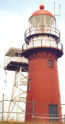
so runs the world away.Just a quick overview.
See below for the index.
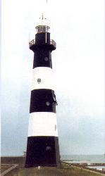
Location:
Build:
Visibility
Material:
Shape:
Levels:
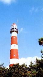
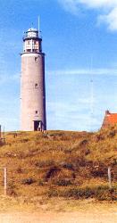
Height:53-27,0N 5-37,6E
1880 - 1881
35 km
cast iron
round
15
55,3 meter
back to index
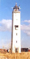
Location:
Build:
Visibility
Material:
Shape:
Levels:
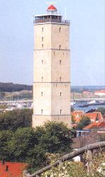
Height:53-21,7N 5-12,9E
1593 - 1594
35 km
yellow brick
square
5
55,5 meter
back to indexLocation:
Build:
Visibility
Material:
Shape:
Levels:
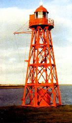
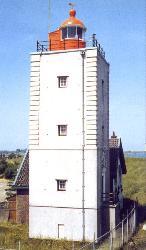
Height:52-56,2N 5-02,6E
1884
15 km
cast iron
hexagon
4
15,5 meter
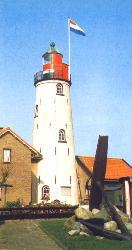
back to indexLocation:
Build:
Visibility
Material:
Shape:
Levels:
Height:52-37,2N 4-37,4E
1833 - 1834
31 km
brick
round
7
34 meter
back to index
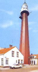
Location:
Build:
Visibility
Material:
Shape:
Levels:
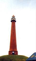
Height:53-11,0N 4-51,4E
1864 - 1864
36 km
brick
round
7
54 meter
back to indexLocation:
Build:
Visibility
Material:
Shape:
Levels:
Height:52-44,6N 5-17,0E
1834
19 km
brick
square
4
17 meter
back to indexLocation:
Build:
Visibility
Material:
Shape:
Levels:
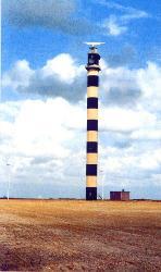
Height:52-27,7N 4-35,0E
1878
36 km
cast iron
round
11
53 metro
back to indexLocation:
Build:
Visibility
Material:
Shape:
Levels:
Height:51-58,3N 4-00,9E
1974
38 km
reinforced concrete
octagon
26
67,5 meter
back to indexLocation:
Build:
Visibility
Material:
Shape:
Levels:
Height:51-24,5N 3-31,4E
1867
26km
cast iron
octagon
5
28,4 meter
back to indexLocation:
Build:
Visibility
Material:
Shape:
Levels:
Height:52-15,0N 4-26,1E
1921- 1922
29 km
brick
square
6
33 meter
back to indexLocation:
Build:
Visibility
Material:
Shape:
Levels:
Height:52-06,3N 4-16,2E
1875
36 km
cast iron
12 sides
10
49 meter
back to indexLocation:
Build:
Visibility
Material:
Shape:
Levels:
Height:52-39,7N 5-35,6E
1844 - 1845
33 km
brick
round
4
27 meter
back to index
Location:
Build:
Visibility
Material:
Shape:
Levels:
Height:53-17,8N 5-03,6E
1864
37 km
brick/cast iron
round
3
54 meter
back to index
Summary site-index
Stamps Russia [Identified stamps][Kargopol][Nostalgic pictures][Occupation Azirbayedjan] [Occupation/territories]
[Perfins][Republics][Revenues][Souvenir sheets][Unknown][Zemstvos][Want list][Links]Stamps Hungary [Perfins][Porto overprint][Revenues][Unknown][Want list][Links] Stamps Denmark [Julemærker][Perfins][Want list][Links] Perfins [Russia][Hungary][Denmark][Links] Whisky [Whisky][Scans of 175 different whiskylabels][Whisky labels][List of (2950+) all my whisky labels] Lighthouses [Lighthouses][175 photos Dutch lighthouses][Lighthouses on Stamps] Miscellaneous Stamps [A lot of Links][Locals Great Britain][Precancels GB/Canada] Miscellaneous [Add url] [Forum][Guestbook][Contact][Banners][Electric clocks]
Copyright © 1988 - 2013 by:
Jan Langenberg
Nederland
All rights reserved. The material
on this site may not be reproduced, distributed, transmitted or otherwise
used, except with the prior written permission
of owner. |
![]()
Last modified